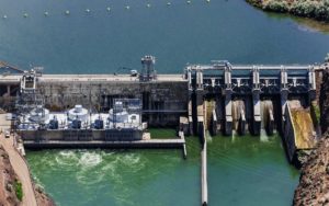
Aerial Photography, Bliss Dam on the Snake River, Near Bliss, Idaho.
Expertise: Defensible extreme-specification forensic and research LiDAR (LASER Scanning) and thermographics, near-infrared & visible band imagery (photography, videography, time lapse, macro- and microphotography & video). Environmental controversies including water temperatures, geotechnics, and erosion volumetrics, architectural illumination. Construction, engineering, and craning operations and incidents. Color management, color science, and human visual acuity relevant to litigation. Certified Level II (Advanced) and Level III (Master, Managerial) Thermographer; FLIR Infrared Training Center. Certified Terrestrial LiDAR operator; theory, planning, and data interpretation; FARO Technologies, GmbH. Certified Aerial Photographer (Professional Aerial Photographers Association, International). Certified Master Aerial Photographer (Professional Aerial Photographers Association, International: one of ~50 to ever receive the award as of 7/18). OSHA 30 Certified (General Industry). Adobe Certified Expert: Photoshop (CS4, CS5, CS6, CC). Adobe Certified Expert: Premiere Pro (CS6, CC). Adobe Certified Expert: Flash Professional (CS5, CS6, CC). Adobe Certified Expert: Web Specialist (CS6). Adobe Certified Expert: Video Specialist (CS6, CC; 1 of 105 in the world as of 7/18). (Inactive) Member, Professional Advisory Board, Stevens-Henager College. (Inactive) Moderator for Adobe's online Photoshop, Premiere, & Flash forums. (Inactive) Lecturer, Law Seminars International.
